06 July
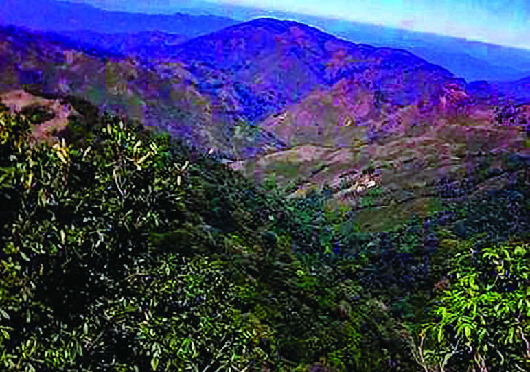
I WENT on a field survey with geology students in 2017 to Ywangan Region in Danu Self Administered Zone. Ywangan town is at an elevation of 4,028 ft. above sea level. It was formed with 28 village tracts and had a population of more than 82,000. It was in Shan State south and can be reached from Aungban-Pindaya road junction. As Ywangan town was surrounded by unspoilt natural beauties it was considered as a virgin land. It is a land where peace and tranquillity prevails.
To Ywangan we go
Hinthada geology field survey group led by Dr. Kyaw Lin Zaw went to Ywangan Region by rail from Yangon Station. We entered Shan State south passing through Thazi and Yinmabin. As we entered Shan State the temperature became cooler. The rail track twist and turns after passing Kalaw and after about half an hour, we reached our disembarkation station in Aungban. Aungban Station to Ywangan was a 42 miles car ride that took us through natural scenes of mountains and hills as well as some pagodas. Euclid trees were all along the road side occasionally dotted by some farm lands. We passed through several big villages such as Myin Twin, Myinjado and Phayagyigon and reaches Ywangan after a car ride of about an hour.
Alechaung Village – our base camp
The geology field survey group set up a base camp at Alechaung Village. It is situated on the west of the Pindaya mountain range. The majority of the villagers were Danu and they were a very friendly and simple people. Of the 135 ethnic nationals in Myanmar, the Danus are the tenth most populous and were one of the ethnic nationals that had lived in Myanmar for the longest time. Danu National Day was held annually on the 8th Waxing Day of Nattaw. Bama, Pa-O and Palaung in addition to Danu lived in the region. Mountains and hills lies on the east of the village while farmlands and plains are on the west of the village. Every five days, there is a market and access to food was very convenient and easy.
The village had two monasteries, named simply North Monastery and South Monastery. Geology field survey group from Pathein had setup their base camp in the North Monastery so our Hinthada Group setup our base camp in the South Monastery. In addition to having access to electricity and water, the South Monastery has a football field that became football practicing ground for our survey students.
The village is a liquor free area where sale and consumption was not made. Villagers were devote Buddhists and the time was when a donation ceremony was being held for young boys becoming novice monks. We were invited to enjoy the food donation made for the occasion which runs for a whole week and villagers from nearby villages were also invited.
Agriculture products of the region
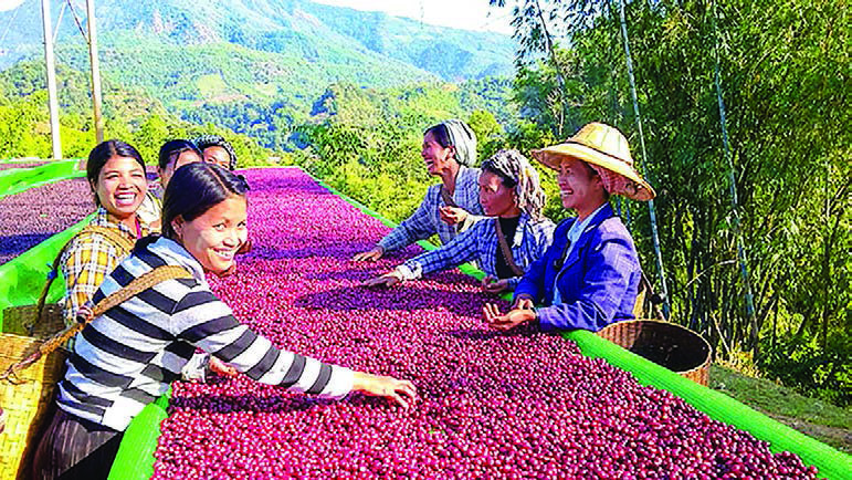
Agriculture was the main mean of livelihood in Ywangan region. Fruits and vegetables such as orange, tomato, cabbage, ginger, avocado etc. were grown but the main products were coffee and tea. Coffee and tea plantations are the usual sight seen at entrance of every village. Ywangan coffee has become known in the world for its quality and was reported to have achieved a Geographical Indication (GI), the same designation that protects the Champagne region in France from copycats. Ywangan coffee beans are of the Costa Rican variety and are grown as a substitute for poppy. The coffee is currently rated at a level of 85 in the global market under the recommendations from American Coffee Specialists. Any grade of 80 or above is considered a specialty coffee. Out of 125 villages in Ywangan Township, about 90 are engaged in coffee plantation with 7,300 acres of coffee farms.
Field survey starts
The field survey starts by studying geological layouts of the area near Alechaung Village. One day, the field survey team conducted a survey of rock formations on Yasakyi Mountain that was on the east of the village. It was the highest mountain in the area where the survey was conducted rising to a height of 6,860 ft. The mountain rises above us imposingly as we reached the foot of the mountain where we took a brief rest before hiking up. We left the village in the morning and we reached the summit of the mountain only at noon. Although the hike up the mountain was tedious and time consuming, the sight waiting at the summit was breathtaking. All the mountains in the area were below us except for some higher peaks of Shan State that were visible afar. Every hiking enthusiast should hike up Yasakyi Mountain near Alechaung Village in Ywangan Township to enjoy the view from the summit as well as the hike up and down the mountain.
Well known areas in the vicinity
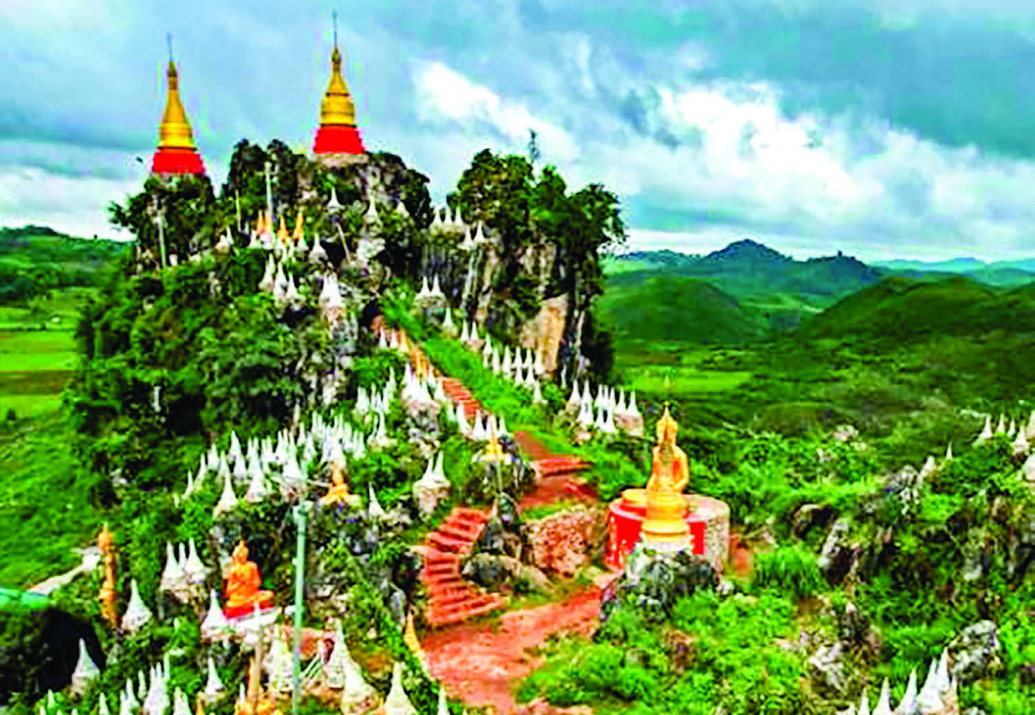
There were many well known areas in the region. To the south of Ywangan Town lies Meinmaye Thakhinma Mountain. There are stairways to the pagoda on top that will take about 15 minutes to climb up.
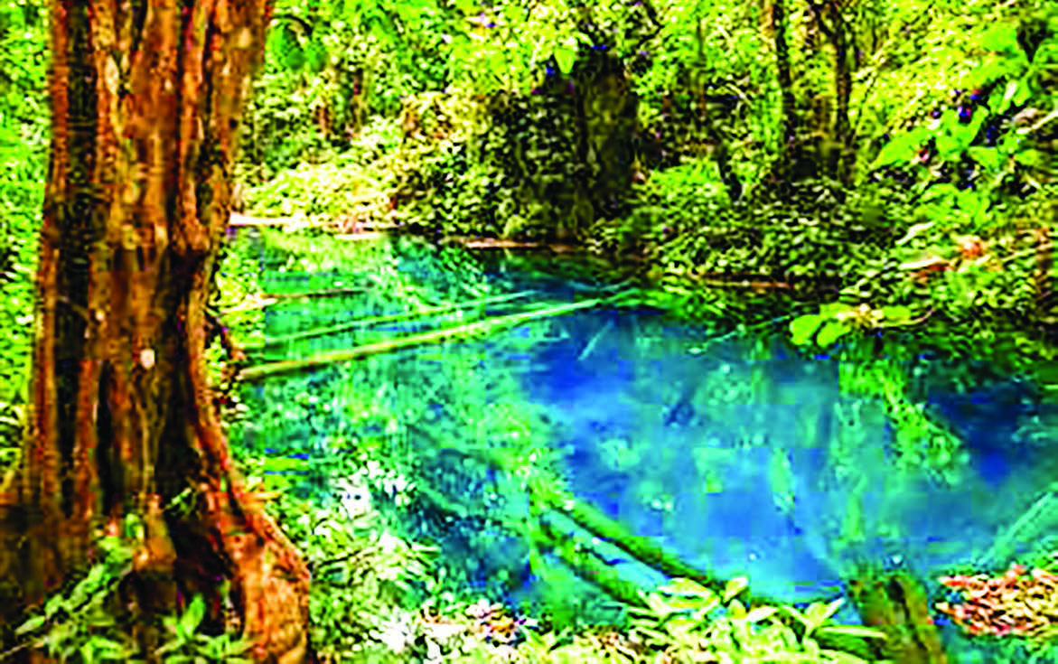
Myathabeik Blue Water Pond and Tawkye waterfall is near Tawkye Village. Blue Water Pond was teeming with small shops selling local products such as herbs, local food, honey, flowers and gift items. There was no scientific explanation made yet for the water in the pond being blue but locals believe that it was the reflection of an emerald bowl (Myathabeik in Myanmar language) at the bottom of the pond. Local superstition was such that littering, washing with the water in the pond, taking water from the pond was not done while care was taken of not speaking any word that can be deemed as offensive or rude.
20-minute walk from Blue Water Pond will take you to Tawkye waterfall. The water in the pond at the bottom of the waterfall was so clear that fish can be seen swimming in it.
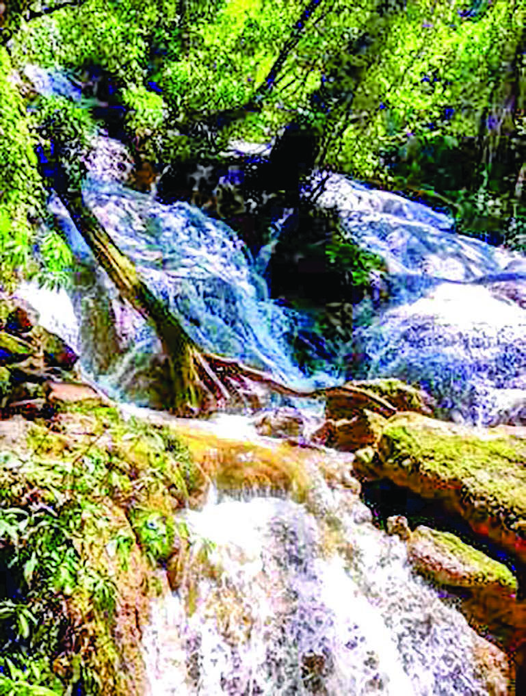
There was even a waterfall right near Alechaung Village. It was a fall that goes down 11 steps or levels. During the time when the waterfall was at its highest flow of water volume, there were considerable numbers of visitors visiting it.
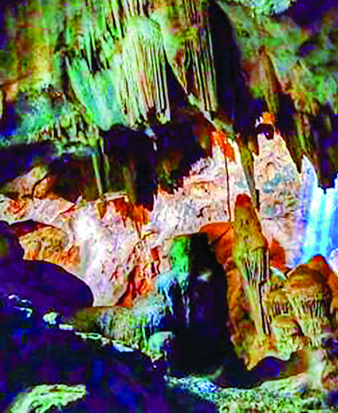
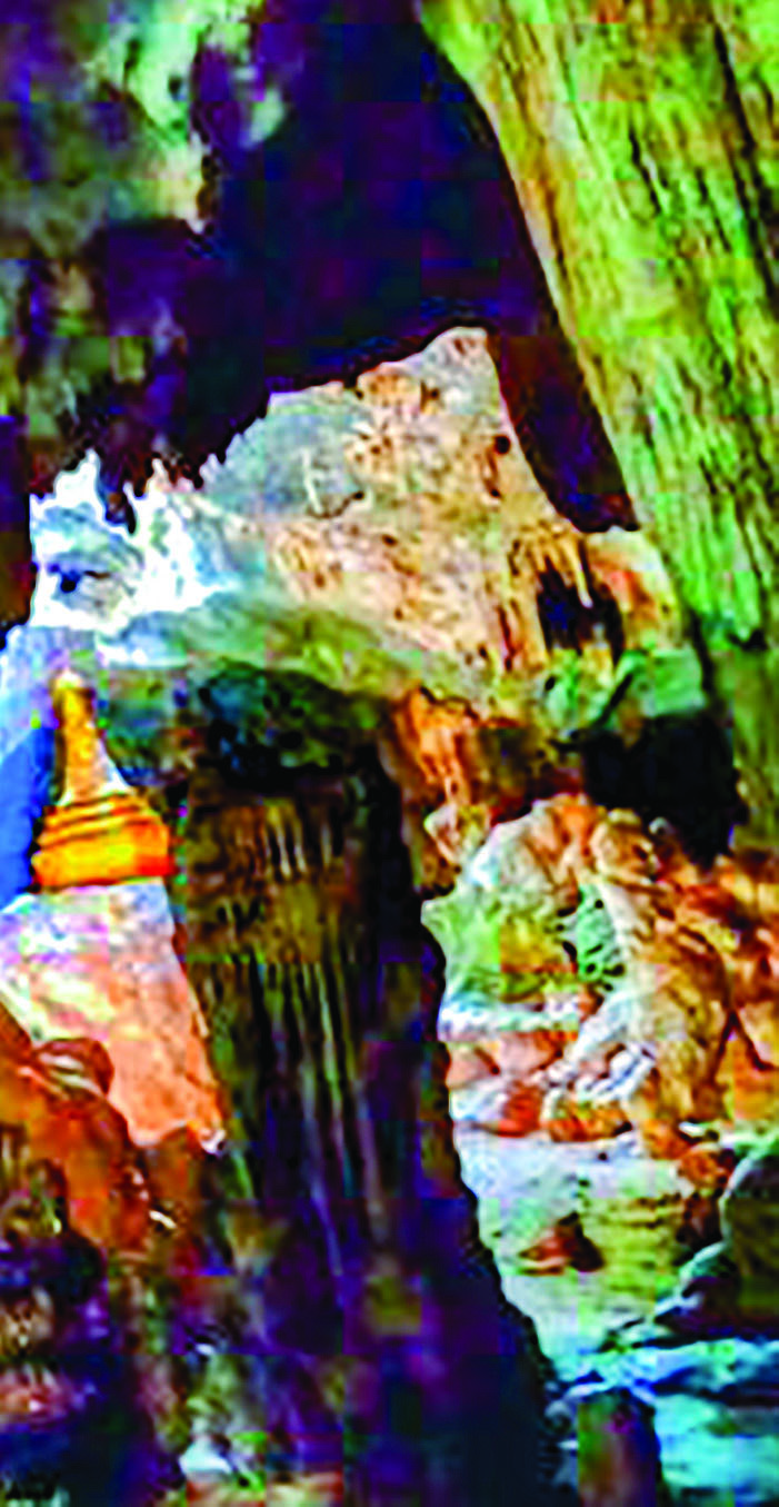
Pyadalin Cave in Ywangan Township is another famous cave. There are in fact two caves the smaller one amount to being a rock shelter while the larger one had nine chambers connected by narrow passages. Three large sink holes bring in natural light into the cave. This cave contains an impressive amount of history reportedly dating back to the Neolithic era. The two caves were only 30 meters apart from one another and some of the earliest wall carvings and paintings in Myanmar were found here along with weapons made of bones and stones by primitive people. According to Wikipedia a superficial investigation of the caves had been performed by American South-East Expedition for Early Man in 1937-1938 and geologist U Khin Maung Kyaw discovered the paintings in 1960. The site was added to the UNESCO World Heritage Tentative List on 4 October 1996 in the Cultural category.
Another unique place is the Yephyu Waterhole near Tatkon Village, Kyantaw Village Tract. It is located southwest of Alechaung Village. The water from this waterhole was not clear but white in color, hence the name Yephyu which mean white water. Locals say bathing with the water from this waterhole eases aches and itches. The place is indeed a virgin area.
The highest peak in Shan State, 7,752 ft. high Ashay Myin Anauk Myin Mountain is also in Ywangan. Taunggyi town can be seen looking toward the east from the summit. Looking west, Meiktila town can be seen too. South of the mountain lies 7,307 ft. high Moelonehein Mountain and to the north lies 7,203 ft. high Pansitpway Mountain. The Ashay Myin Anauk Myin Mountain is home to rare flowers as well as birds and animal species. The summit of the mountain can be reached either from Ywangan side or Pindaya side. The mountain was located about 6 miles southwest of Alechaung Village.
Another significant place is a small pillar marking the place where ash of Colonel Ba Htoo was buried. Major Ba Htoo at that time led the fight against the Japanese in upper Myanmar in 1945. The plan was for the Myanmar army under General Aung San to revolt against the Japanese in end March but Major Ba Htoo declared unilateral war against the Japanese on early March diverting attention from General Aung San who led the entire Myanmar army uprising at a later date. Major Ba Htoo’s action contributed toward driving the Japanese fascist forces out of the country but he succumbed to a severe case of malaria. The plaque on the pillar simply stated “Martyr hero Colonel Ba Htoo passed away on 8:10 p.m. 2 June 1945 in Ywangan Township Telu Village. His ashes were buried here.” It was reported that when Major Ba Htoo passed away, he never knew of his promotion to colonel by General Aung San. A monument honouring Colonel Ba Htoo was put up in Aungban but the small pillar in front of Telu Village Basic Education Primary School was the spot where his ashes were buried. Even though it was a considerable walk through humid valley and over a rickety bamboo bridge across a river, we took the long walk to honor and salute our martyr hero.
I was there as part of a geological field survey but I would have gladly made the trip as a tourist to enjoy again all that I’ve seen and been to in Ywangan region.
(Translated by Handytips) By Ye Yint Aung (Geology)