By THAN HTUN (MYANMAR GEOSCIENCES SOCIETY)
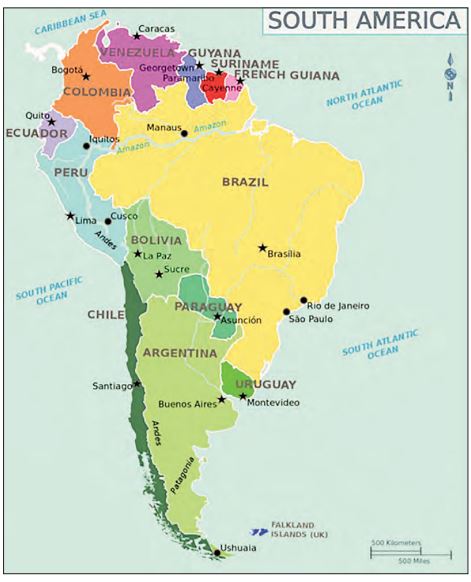
SOUTH America, fourth largest of the world’s continents. It is the southern portion of the landmass generally referred to as the New World, the Western Hemisphere, simply the Americas. The continent is compact and roughly triangular in shape, being broad in the north and tapering to a point-Cape Horn, Chile-in the south.
South America is bounded by the Caribbean Sea to the northwest and north, the Atlantic Ocean to the northeast, east, and southeast and the Pacific Ocean to the west. In the northwest, it is joined to North America by the Isthmus of Panama, a land bridge narrowing to about 50 miles at one point. Darke Passage, south of Cape Horn, separates South America from Antarctica.
Relatively few islands rim the continent, except in the south. These include the glaciated coastal archipelagoes of Argentina and Chile. The Falkland (Malvinas) Islands are east of southern Argentina. To the north, the West Indies stretch from Trinidad to Florida, but those islands usually are associated with North America. Of the remainder, most are small oceanic islands off the coasts of South America, including the Galapagos Islands, Ecuador, in the Pacific Ocean.
South America has a total of about 6,878,000 square miles or roughly one-eighth of the land surface of the Earth. Its greatest north-south extent is about 4,700 miles, from Point Gallinas, Columbia, to Cape Horn, while its greatest east-west extent is some 3,300 miles, from Cape Branco, Brazil to Point Parinas, Peru. At 22,831 feet above sea level, Mount Aconcagua, in Argentina, near the border with Chile, is not only the continent’s highest point but also the highest elevation in the Western Hemisphere. The Valdes Peninsula, on the southeastern coast of Argentina, includes the lowest point, at 131feet below sea level. In relation to its area, the continent’s coastline — some 15,800 miles in length-is exceptionally short.
Name
The name America is derived from that of the Italian navigator Americo Vespucci one of the earliest European explorers of the New World. The term America originally was applied only to South America, but the designation soon was applied to the entire landmass. Because Mexico and Central America share an Iberian heritage with nearly all of South America, this entire region frequently is grouped under the name Latin America.
Physical Divisions
ysical Divisions There are three physical divisions in the South American Continent. Western mountains and highlands, Eastern Highlands and Central Lowlands.
Western Mountains
In the Western mountains and highlands region, Andes is South America’s primary mountain system. The Andes is the world’s longest continental mountain range, about 4350 miles long and stretching through the entire continent in the north-south direction from the Isthmus of Panama to the strait of Magellan. The Andes covers part of seven countries: Venezuela, Colombia, Ecuador, Peru, Bolivia, Chile, and Argentina. The Andes maintain system occupies hundreds of peaks more than 4,500 meters tall, many of which are volcanic (part of Pacific Ring of Fire). In Northern Andes, Mountain Chimborazo and Mount Cotopaxi are active volcanic peaks. The widest Central Andes covers Altiplano/ Andean/ Bolivian, the second-highest plateau in the world. Lake Titicaca (largest in South America) and Lake Poopo are located in Central Andes. Central Andes includes the Atacama Desert, the driest non-polar desert in the world, between the Chilean Coast Range and Andes. South Andes includes the highest peak in the Andes- Mount Aconcagua (6,962 metres) in Argentina, near Chile border – continent’s highest point, also highest peak outside Asia. It also includes the highest active volcano in the world, Ojos del Salado, which lies on Argentina and Chile border.
Eastern Highlands
The rocks of Eastern Highlands are older than the Andes- made up of very old rocks and form an undulating surface with a gentle slope. It consists of three main plateaus: Guiana Highlands/Shield, Brazilian Highlands and Patagonia Highlands. Guiana Highland/Shield is a 1.7 billion years old Precambrian Craton. It lies north of the Amazon River and south of the Orinoco River. It acts as the divider between Amazon and Orinoco basins and it is known for being the highest waterfall in the world. Angel Falls (3133 ft) high on River Caroni in Venezuela. Brazilian Highlands covers most of the eastern, southern and central portions of Brazil. It includes Plateau of Mato Grasso Plateau of Borborema. Patagonian Plateau is located primarily in Argentina and is bounded by the Andes in the west and the Atlantic Ocean to its east. It is the semiarid scrub plateau that covers nearly all of the Southern portion of mainland Argentina. It is also known as Patagonian Desert/Patagonian Steppe. Patagonian Plateau is the largest desert in Argentina and is the 8th largest in the world by area.
Central Lowlands
The Central Lowlands lie between the Andes and the Eastern Highlands and cover more than half of the continent’s area. Most of Central Lowlands is sparsely populated because of leached soils, but Pampas in Argentina are very fertile. Lowlands consist of three river basins: Llanos basin, Selva’s basin and La Plata Basin. Llanos basin was created by the Orinoco River and its tributaries. Selva’s basin was formed by Amazon and its tributaries. Amazon is the world’s largest river by volume. This basin is covered with Equatorial Rain Forest (Lungs of the world). La Plata basin was created by Parana, Paraguay and other rivers. This basin forms an estuary known as Rio-de-la Plata which serves as an excellent harbor.
Islands
Several noted island groups are usually affiliated with the physical region of South America. The three significant islands are the Galapagos Islands, the territory of Ecuador, the Falkland Islands, known as Malvinas is an overseas territory of the UK and Easter Island and Robinson Crusoe Island in the Pacific Ocean which is now controlled by Chile. The islands contributed to scientist Charles Darwin’s evolution theory and natural selection concept. Galapagos National Park has established in 1959; first in Ecuador; a UNESCO World Heritage Site.
Major Lakes
Lake Titicaca is a freshwater lake and is the largest lake in South America. It is located on the border of Bolivia and Peru and is the highest navigable lake in the world. Lake Poopo is situated in Bolivia. Lake Maracaibo in Venezuela is a tidal bay and one of the major oil-producing regions.
Inhabitants
The original inhabitants of South America are believed to have descended from the same Asiatic peoples who migrated to North America from Siberia during the most recent (Wisconsin) ice age. Few of these peoples, however, survived the arrival of Europeans after 1500, most succumbing to disease or mixing with people of European and (especially in Brazil) African Origin. Some parts of continents are now industrialized with modern cities, but the people in rural areas still follow an agricultural way of life. The wealth of mineral products and renewable resources is considerable, yet economic development in most of the continent lags behind the more industrially advanced regions of the world. Nonetheless, concern has arisen about the rapidly increasing and often destructive exploitation of these resources.
Culture areas
Many South Americans resist recognizing ancestry as being socially significant, especially as language, religion, and other cultural aspects tend to cross ethnic lines. In practice, however, an individual’s ethnic background can be a factor in determining social status, educational attainment, and economic opportunities. Ethnic distinctions can be divided into three broad types of regions based on the predominant ethnic element in what otherwise are mixed populations, with those three elements being people of predominantly American Indian, African and European descent. Those regions have been defined to a large extent since the end of the colonial period. The people within them, however, are not of uniform ancestry but rather are clustered into different cultural groups. Moreover, ethnicity in South America is often self-determined.
Geologic history
The geologic history of South America can be summarized in three different developmental stages, each corresponding to a major division of geologic time. The first stage encompassed Precambrian time and was characterized by a complex series of amalgamations and dispersals of stable blocks of proto-continental crust called cratons. The second stage coincides with the Paleozoic Era, during which time the cratons and material accreted to them contribute to the formation first of the Supercontinent Gondwana and then of the even larger Pangea. The third stage, in which the present continental structure emerged, occurred in the Mesozoic and Cenozoic eras and includes the breakup of Pangea and Gondwana, the opening of the South Atlantic Ocean, and the generation of the Andean cordillera.
The present tectonic framework of South America consists of three fundamental units: the ancient craton, the relatively recent Andean ranges, and a number of basins. Five cratons – Amazonia, Sao Francisco, Luis Alves, Alto Paraguay, and Rio de la Plata – represent the Precambrian core of South America, and (with the exception of the Alto Paraguay craton) those now appear as upward massifs arrayed from north to south in the immense eastern portion of the continent; a number of other Precambrian crustal blocks also were accreted along the margins of South America cover geologic time.
The lofty ranges and intermontane plateaus of the Andes rise along the entire western margin of the continent and represent the collision in the Cenozoic Era of the Pacific and South American plates brought by the opening of the South Atlantic. Finally, vast, down warped, sediment-filled basins are found between the cratons and along the entire eastern margin of the Andes.
Mineral Resources
South America is relatively rich in mineral resources. However, they are highly localized: few countries have a good balance of fuels and raw materials within their boundaries, and two countries, Uruguay and Paraguay, are nearly devoid of mineral wealth. Nevertheless, South American economies have traditionally relied on a foundation of mining, fishing and forestry, and non-exportable manufactures.
Large quantities of oil and natural gas are found in several areas in South America. The greatest quantities are located in the sedimentary layers surrounding Venezuela’s Lake Maracaibo and the adjacent Caribbean coastal margin. Venezuela, Bolivia, Ecuador, Argentina and Chile are oil producers and exporters.
South America contains about one-fifth of the world’s iron ore reserves. Brazil and Venezuela are supplying domestic iron and steel industries as well as significant exports. Nonferrous metals are abundant in South America. The continent’s copper reserves which are found in Chile and Peru represent more than one-quarter of the world’s known reserves. Bolivia ranks among the world’s four of five largest tin producers. Significant tin deposits also occur in Brazil’s western Amazon basin. Lead and zinc are dispersed among many countries but are found in the greatest abundance in the central Andes of Peru, Brazil, Bolivia, and northern Argentine Andes. Brazil is South America’s leading gold producer, with deposits in the Amazon basin.
Animal life
South American animal life is particularly rich and well-diversified as a result of the wide range of habitats. Moreover, because of its isolation from the rest of the world during the Paleogene and Neogene times (about 66 to 2.6 million years ago), the South American landmass is characterized by considerable biological originality. There are some similarities between South America’s fauna and that of other continents as a result of past geologic developments. Regarding principal faunal types, there are 2,700 species of freshwater fishes that have 89 families. The range of mammals includes those that existed on the continent before its complete isolation and those that migrated to and from South America. Later, tapirs, deer, bears, rabbits, and many others arrived, as did the camel family, which gave rise to vicunas, and guanacos some 6,000 years ago. Amphibians are well represented by caecilians, toads and varieties of frogs. Reptiles include a great variety of turtles and tortoises, crocodiles, caimans, geckos, and many snakes. Most South American insects, spiders, crabs, centipedes, and millipedes are found nowhere else in the world. Most of the best-known arthropods (e.g., mosquitos, sandflies, and kissing bugs) are responsible for the transmission of human diseases such as dengue and malaria.
References:
1. Wikipedia, the free encyclopedia
2. Hector Fernando Avila, B, Vector A. Ramos, C. W. Minkel, Jean P. Dorst, et al., Britannica
3. Paracham classes