December 21
By THAN HTUN (GEOSCIENCE MYANMAR)
Introduction
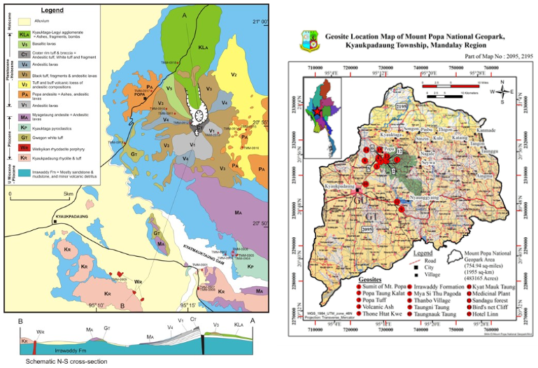
Mount Popa, in reality, forms the largest and southernmost of the group of Lower Chindwin volcanoes. The area occupies about 500 square miles and lies between 20° 40’ and 21°3’N Lat and 95°6’ and 95° 22’ E Long, and is represented on the following one-inch Burma Survey map sheets, 84/04, 0/8, P/1, P/2, P/5, and P/6. It is situated in Mandalay Division in the Myingyan plane of Central Myanmar. Although the region is located in the dry zone of Myanmar, the weather of Mount Popa is cooler than that of surrounding regions due to the isolated high mountain of 4,981 feet. Relatively, the Mount Popa area is the most convenient and accessible place in Myanmar. One can reach Mount Popa by motorcar, train, and plane via NyaungU airport from Yangon and Mandalay. Mount Popa National Geopark is the first Geopark in Myanmar, which is a collaborative effort by the Myanmar Geosciences Society and the Ministry of Natural Resources and Environmental Conservation.
What are Geoparks?
A UNESCO Global Geopark is like nowhere else on Earth. It is somewhere to touch, explore and connect with a part of the Earth’s history. As an area of unique geological interest, a Geopark is a place where you can discover extraordinary landscapes, places and people. (UNESCO)
Geodiversity of Myanmar
Myanmar, the second largest country in Southeast Asia, occupies a geologically critical position in the northeast corner of the Indian Ocean, where the northern end of the Sunda-Andaman arc, the world’s second-largest arc system, has collided with the Indian continent in the Naga Hills and juxtaposed with the eastern end of the India-Asia collision zone and the Himalayas to the east. Myanmar has a disproportionately large number of world-class metallic mineral deposits for its size and population, producing offshore and onshore reserves of gas and oil and an abundance of gemstones, reflecting the country’s varied geology. This includes the post-Jurassic Popa-Loimye magmatic arc in the west and the continental Shan Plateau welded to a Triassic island arc in the east. ( A H G Mitchell, 2018)
The volcanic line of Central Burma (Chhibber 1934) forms the axis of the Central Lowlands extending from Mt Popa volcano northwards to Taungthonlon volcano. South of Mt Popa, its probable extension is indicated by doleritic sills in the Pegu Yoma and volcanic on Narcondam and Barren Islands. (Marshall et al. 2017)
Potential Geoparks
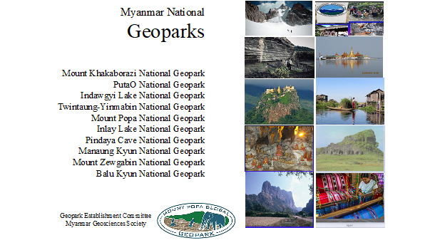
Based on the information on protected forest areas, the Myanmar Geosciences Society proposed ten potential Geoparks throughout the country. Many more Geopark areas concerning natural caves in karst areas along the Shan-Tanintharyi region exist. The potential Geoparks proposed by the Myanmar Geosciences Society are as follows: —
Mount Popa National Geopark
Since 1920, an area of 2,961 acres was demarcated as National Forest in the Mount Popa area, and it extended up to 128.54 square kilometres in 1989. The Popa Mountain Park was established with UNDP’s aid in 1993. In 2007, the Forestry Department formed the National Institute of Biological Resources and International Cooperation Unit for Biodiversity and Environmental Conservation to conduct research. The biodiversity of Mount Popa has been studied in collaboration with NIBR and the National Institute of Biological Research, Incheon, Korea, in 2014 and the compilation of medicinal plants of Mount Popa in 2016.
Due to fertile soil, the land areas are extensively cultivated and yield various fruits such as bananas, mangoes, papaya and abundant products of toddy palms. Natural plants are formed as Dry Than-Dahat Forest, Dry Mixed deciduous forest, Scrub Indaing Forest, Dry Hill Forest and Grassland, especially in Mount Popa’s southern and eastern parts. The Forestry Department controls more than 360 famous local herbal medicinal plant species. Floras are mainly made of teak, Pyinkado, Tamalan, and various varieties of bamboo. Faunas include mainly jungle pigs, cats, monkeys, mammals, reptiles, and 45 species of birds.
The Mount Popa area has a remarkably rich geodiversity that includes varied geology, landforms, and assemblages of associated features and processes. Some geological features can even be considered as world-class. Because geodiversity has a range of values in many ways, and as human activities and urban development now threaten it, geoconservation is essential for the well-being of present and future generations. Geodiversity and geoconservation deserve more attention in Myanmar.
Geology
Regarding gravitational collapse and explosive eruptions of Mount Popa, Alexander Belousov and et al. described as follows: –
Mount Popa is one of the best-preserved volcanoes in Myanmar. The separately standing complex volcanic edifice is composed of lava flows and domes (basalts to dacites).
There are questionable reports of possible volcanic activity ~800BP and 442 BC. The majority of the young volcaniclastic fans represent typical debris avalanche deposits (S = 27 square kilometres, V = 3 sq km, H = 1.1 km, L = 11 km, H/L = 0.1) composed of block facies. In its eastern, the debris avalanche is covered by a deposit of scoriaceous PF. The Edifice of Mount Popa was destabilized by the intrusion of magma, and the collapse triggered the explosive eruption. No blast deposit was found in the area, so the collapse scenario was of Shiveluch type. Ar-Ar dating of the summit lava dome and the lava flow truncated by the avalanche scar provide zero age – thus, they are very young. Buried paleosol under the avalanche deposit provided C14 calibrated ages 17660-17220BP, 12820-12650 and 8590-8400 BP. Thus, the avalanche and the PF were deposited 8000BP. The paleosol contains thin layers of fine-grained ash, indicating Mt Popa’s eruptions at the beginning of the Holocene. Paleosol on top of the volcaniclastic provides a calibrated C14 age of 2740-2640 BP. The uppermost paleosol contains no ash layers. Thus, there is no geological evidence of explosive eruptions of the volcano at the end of the Holocene.
Alexander Belousov et al concluded that the latest period of volcanic activity of Mount Popa took place at the beginning of the Holocene. It included several mild explosive eruptions, probably of Vulcanian type ~ 12700-8500BP, followed by large-scale edifice collapse ~8000 BP, then followed (probably immediately) by strong magmatic eruption with deposition of the PF. They have not found shreds of evidence of the eruptions ~800BP and 442 BC; they could be of very small scales or possibly were misinterpreted nonvolcanic events: crater wall collapse, mudflows, etc.
Petrified Forest
The Mount Popa Global Geopark Development Committee was formed in December 2016. It conducted frequent field activities and discovered petrified forests in the sandstone of the Irrawaddy Formation, mainly west and southwest of Mount Popa around Thanbo Villages. The longest fossil tree is more than 22 metres long and two metres in diameter. Many tree trunks are at the top of the hills and along the creeks. In August 2017, Thailand-Myanmar collaboration on petrified wood research and conservation Dr Nareerat Boonchai and party investigated the fossil woods of Mt Popa Geopark and proposed a further detailed research programme for palaeobotany and related subjects.
The mammalian fossils
The mammalian fossils, especially teeth, jaws and bones of ancient elephants, deer, gavialis, tortoises, cattle, etc., are found. In April 2018, vertebrate palaeontologist Dr Yupa Thesod from Chaing Mai University, Thailand, inspected all the tooth and jaw fossils of ancient elephant and their ages of Mount Popa Geopark. The fossils were found in the sandstone of the Irrawaddy Formation during farming. Most of the fossils are fragmented, but some are still complete, which suggests that these fossils were transported not far from their origin. According to the tooth morphology, the proboscidean fossil can be classified at least into five species, including Stegolophodon sp. 1, Stegolophodon sp. 2, Stegodon primitive form, Stegodon advanced form and probably Mammut?/Sinomastodon?. These fossil assemblages suggest that the geological age of this area is Miocene and Pliocene. However, the stratigraphy and sedimentology of the fossil locality should be done in more detail (Yupa Thasod and Than Htun 2018).
Cultural Heritage
The cultural and religious heritage of the Mount Popa Geopark includes astrology, alchemy and the worship of Nats. Astrology to the Burmese meant not only the methods of tracing the courses of the planets and their influence on mortals but also the ritual by which the planets were appeased and made to withdraw their influence and impact.
Alchemy also came to Myanmar from India, but Burmese alchemy became a religious cult. The Burmese alchemists did not merely seek the power of transforming base metals into gold; they also had the noble aim of evolving an eternally youthful body, which would be an answer to the perpetual human lament that beauty and youth must prevail.
The worship of Nats was purely native in origin and developed out of that form of animism, which still prevails among some of the hill peoples of the country. The most important of the thirty-six Nats are the Lord of the Great Mountain and his sister, Lady Golden-Face, whose abode was on Mount Popa, an extinct volcano in central Myanmar. In the ninth century, they became the guardian gods of Bagan and its kings. As permitted by the Bagan King, traditional Myanmar believed that Taungkalat had been home to thirty-six Nats forever. There was an annual Nat feast on Mount Popa itself, at which hundreds of animals were offered as a sacrifice to the Lord of the Great Mountain and Lady Golden-Face during the Bagan Dynasty. Still, no special offers for animals are found these days (Than Htun and Nareerat Boonchi, 2022).
Archaeological Heritage
Regarding archaeological heritage, a lot of ancient traditional iron furnaces in the Bagan Dynasty were discovered near Thanbo village. King Anawrahta, when his brother King took power at Bagan, based at Popa village, gathered soldiers and trained them secretly to take the throne. He made weapons with iron concretions from Irrawaddian Sandstone by using the furnace. He used horses and elephants in fighting, and there is a royal elephant pasture near Shwezitaing Village. According to archaeological data, the Popa region has been inhabited by humans since 10,000 years ago. The Mount Popa region is at the heart of the famous Anyathian culture in Myanmar. The estimated population in this region is currently about 291,561 people in 339 villages.
Mount Popa National Geopark
Upon permission of the Ministry of Natural Resources and Environmental Conservation, the Myanmar Geosciences Society comments its study in the Mount Popa area to establish the First National Geopark towards UNESCO Global Geopark on 9 December 2016. After collaboration effort by the Forest Department, the Myanmar Geosciences Society, the Department of Geological Survey and the Mineral Exploration and Geology Departments of various Universities, the Ministry of Natural Resources and Environmental Conservation has released Notification 152/2023 recognizing Mount Popa National Geopark starting from 6 December 2023. We warmly welcome Mount Popa National Geoparks and other potential Geoparks for education, conservation and sustainable development in the Mount Popa region.
References:
1. A Belousov, M Belousova, Khin Zaw, M J Streck, I Bindeman, S Meffre, P Vasconcelos, 2018: Holocene eruptions of Mt Popa, Myanmar.
2. Hla Min, 2015: Geological, Petrological and Tectonic Significance of Volcanic Rocks exposed in Popa Area, Kyaukpadaung Township, Mandalay Region.
3. Marshall T R, Amos B J, Stephenson D 2017: Base metal concentrations in kaolinized and silicified lavas of the Central Burma volcanic.
4. Mitchell, A H G, 2018: Geological Belts, Plate Boundaries, and Mineral Deposits in Myanmar; MPRG & Oxford, UK.
5. Than Htun and Nareerat Boonchi, 2022: Myanmar’s Mount Popa: geoheritage and its progress towards geopark, the 6th International Palaeontological Congress, Khon Kaen, Thailand.
6. Yupa Thasod and Than Htun, 2019: Proboscidean Fossil from Irrawaddy Formation at the Mt Popa Geopark, Myanmar.