By THAN HTUN (GEOSCIENCE MYANMAR)
(EPISODE:30)
MR K A K Hallowes commenced his tenure as a GSI geologist in 1905 and concluded his service upon retirement in 1926. Noteworthy entries in the Records of the Geological Survey of India indicate his field activities and contributions. Specifically, Mr Hallowes returned from field duty on 14 May 1917 and subsequently was assigned to the Central Provinces, departing for field duty once again on 4 November 1917. Following this assignment, he returned from Burma on 6 April 1919. Notably, he was granted combined leave for one year, effective from 14 July 1919. One of his significant contributions pertained to the geology of Myanmar, notably reporting on the coal seams of the foothills of the Arakan Yoma in 1921. Due to space constraints, the aforementioned details have been succinctly extracted as follows: -
On the Coal Seams of the Foot-Hills of the Arakan Yoma, Between Letpan Yaw in Pakokku and Ngaphe in Minbu, Upper Burma
Introduction
Commencing the examination of the coal belt from a point a short distance to the south of Tazu, which lies to the southwest of Pauk in the Pakokku district, beyond which point the investigations of my colleague Mr Cotter did not extend, I examined the seams mapped by the late Mr H S Bion as far south as Ngaphe I the Minbu district, i.e. over a distance of rather than 100 miles. At the northern end of the belt, coal occurs not only at Tazu but also at Letpanhla, some 60 miles west of Pakokku; this has already been investigated by Mr Cotter. The same observer and Mr Sethu Rama Rau also examined the geology of the southern part of the belt near Ngaphe. The geology of the intermediate portion, which, as stated above, continues for more than one hundred miles, had been admirably mapped in detail by Mr Bion. All these observers, in the course of mapping the geological formations, had indicated on their maps some of the outcrops of the coal seams. Still, a further examination of the latter had been postponed pending the completion of Mr Cotter’s investigation of the more promising coalfield near Tazu.
Near Kyaukset, some 30 miles southwest of Minbu, coal was, at the time of my visit in November 1918, being mined by Maung Mit on behalf of Maung Tun Aung Gyaw, late Municipal Secretary of Thayetmyo. By 15 November of that year, about 35 tonnes had been sent away, while 10 tonnes were stacked at the mine; in all, therefore, 45 tonnes of coal had been excavated from this occurrence. South of Kyaukset, the coal belt continues east of Kyet-u-bok, west of Kyaukpe and Magyisan, and as far as Yenanman in the Minhla Township.
Geology
The coal-bearing rocks: The coal is confined almost entirely to (1) the Shwezetaw Sandstones (Lower Pegus), which Mr Cotter has shown to contain near Ngape the fossil beds designated by him D E & F, (2) the Yaw Shales (Upper Eocene), which the researches of the same observer along with those of Mr Bion have shown to be characterized by the zone of Velates schmiedeli, occurring on the top of this stage, and which, near Ngaphe (Minbu), has been designated “G “ by Mr Cotter, and finally (3) the Pondaung Sandstones (Upper Eocene), which west of Kinmungyon from the Nwamataung hill range, and near Ngape contain Mr Cotter’s fossil bed H. Coal is generally absent from the Upper Pegus; the same is true of the Tabyin Clays and Tilin Sandstones, for although large areas of these rocks were explored not a single coal-seam was observed in them.
Regarding the rocks containing the coal seams, Bion observed that the Shwezetaw sandstones (Lower Pegus) near Ngahlaingdwin are unfossiliferous; at latitude 20° 58’fossil wood begins to occur in them, and in some places, they contain so much of it, that they resemble or might easily be mistaken for beds of the Irrawaddy Series. The following section from the upper to the lower horizons through the Yaw Stage, the most important of the coal-bearing stages, is given by Bion: -
1. Calcareous sandstone with Operculina; this fossil is always strictly confined to the Yaw Stage.
2. Zone of Velates schmiedeli; Velates does not occur N. of 21° 6’.
3. Shales
4. Coral limestone; 2’ thick, with small gastropods. This bed is not found north of 21° 5’ because of the prevalence of arenaceous facies; below it is a bed of sand containing a profusion of large Ostraeae.
5. Shales
6. Shales with Nummulites yawensis, Cardium thetkegyinense etc. This horizon can be traced through the Yaw Stage as far north as Tazu.
7. Coal and carbonaceous shale.
8. Shale with silicious bands and septaria.
9. Limestone band; 1’- 2’ thick, with small Nummulites and Operculina.
This section indicates, therefore, that the lignite is Upper Eocene in age.
The massive sandstones that underlie the Yaw Stage were named by Cotter the “Pondaung Sandstones” and were found by Bion to have a thickness of 3,000 ft. in the coal belt, and to be characterized by fine-grained concretions of harder matter, two hundred feet from the top of this group they enclose a fossil wood zone. These rocks are usually unfossiliferous, but, as Bion points out, the fossils that he found at rare intervals show that they are “in the main marine.” He further draws attention to the fact that when they are traced northwards, “there is a gradation to more shallow-water facies.”
Dr Cesare Porro has divided the Tertiary beds near Ngahlaingdwin into seven sub-divisions, which, from the work of Bion, can be correlated with the sub-divisions adopted by Mr Cotter in other parts of Burma. His sub-divisions 2 (“lignite-bearing shales with beds containing foraminifera”) and 3 (“alternations of sandstones and shales with beds containing foraminifera”) represent Mr Cotter’s Yaw Stage, which is the chief coal-bearing horizon of the belt.
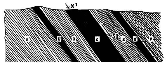
Folding of the coal seams
In the Kyaukset area some 30 miles southwest of Minbu, the coal seams, interbedded between Eocene sandstones and shales, have been folded along with those rocks and show signs of great contortion. (Due to space constraints the table of coal seams could not be included.)
The opening up of the coal seams
The seams in each of the localities enumerated in the preceding table were cleared and opened up by prospecting trenches and pits. The coal, as excavated from these seams, is a hard black lignite with a conchoidal fracture and possesses the lustre and appearance of pitch. With this, black lignite is sometimes associated, for instance, in the Kywe-u Chaung near Kywe-u, a yellow fossil resin.
The roof and floor of the seams
The roof and floor of the seams are composed either of soft Upper Eocene or Lower Pegu sandstones or of light grey or dark reddish-brown Upper Eocene shales more or less decomposed into ochreous clays. The roof and floor are, therefore, distinctly bad, and extensive timbering would be necessary.
Thickness
An examination of the foregoing table will show that the thickness of the seams other than those that are only a few inches thick varies in general, from 1’0” to 3’4”. Near Kyaukset, some 30 miles southwest of Minbu, the main seam attains a thickness of 4’7” but dips at 60°. Only one seam was found to attain a thickness of five feet; it occurs in the Paung Chaung 2 miles west of Myaung-u.
The Burmans of the locality say that the seam was worked in the days of King Mindon when there was a cart track from it to the Mon River and that the coal was sent down on rafts along that river to the Irrawaddy.
Types of coal seams
Five different types of coal seams occur along the Tazu-Ngaphe Coal belt. Type I consists of a seam of solid lignite free from shale; Type II is composed of lenticles of lignite scattered through a bed of dark carbonaceous shale; Type III is the same as Type I except that it is characterized by a stratum of solid lignite along the base of the seam; Type IV consists of an upper horizon of solid lignite above a stratum of carbonaceous shale through which are scattered numerous lenticles of lignite; finally Type V is composed of lignite which suddenly thins and thickness from point to point, to give the same an almost nodular character.
Quantity
Kyaukset: The total thickness of coal in the three horizons of the Kyaukset area is 9’ 8”. As the coal measures rather less than 40 cubic feet per tonne for every 1,000 feet of outcrop to a depth of 20 feet, there are at least 4,500 tonnes of coal available.
Lenticularity: The uppermost main seam, when traced along the strike, thins from 2’9” to 1’9” of available coal in 102 yards, while the intermediate seam rapidly diminishes from 4’7” to 2’9” in the short distance of 55 yards.
A few of the most interesting cases of the lenticularity of the seams will now be given: -
1. The seam at (37) in the Tetoma Chaung W of Kywe-u, when traced for a few yards along the strike, diminishes in thickness from 3’6” to 2’2”.
(ii) Though the Shwezetaw Sandstones are very finely exposed as great bars of rock across the Thanat Chaung west of Tanyauktin, not a trace of coal was observed in them. It, therefore, appears that the coal seam of Kinmungyon, further north, thins out altogether to the south before this river is reached.
(iii) In the Paung Chaung, 2 miles west of Myaung-u, the 5’2” seam lignite, when traced to the south for 432 feet across the bends of the river, is found at (Z1) to have diminished in thickness to 3’10”.
(iv) Interesting cases of the lenticular nature of the coal seams occur near Kyaukset.
Quality
The coal of several seams is poor in quality, for it consists of lignite in every case, the grade of which is lessened by the incorporation of considerable quantities of carbonaceous shale and sand.
Handpicked coal was analyzed by the Burma Oil and the British Burma Petroleum Companies with the following results: -
|
Locality of coal |
Main coal seam near Kyaukset |
Coal from Kyaukset |
Near Kinmungyon (Cotter) |
|
Analyst |
BOC |
BBPC |
GSI |
|
Moisture |
10.59 |
7.56 |
4.84 |
|
Ash |
4.58 |
4.08 |
5.63 |
|
Fixed carbon |
46.69 |
52.82 |
54.64 |
|
Volatile matter |
48.73 |
35.51 |
34.89 |
|
Sulphur |
.. |
2.55 |
.. |
|
Calorific value |
2/3 that of Bengal coal |
5,750 calories or 10,350 BTUS. |
.. |