By THAN HTUN (GEOSCIENCE MYANMAR)
EPISODE: 27
H S Bion joined the Geological Survey of India on 28 February 1911 and assumed the role of Curator on 14 November 1911. He served as Curator at the Geological Museum until 31 May 1912. On 1 June 1912, he participated in fieldwork in Kashmir alongside Mr Middlemiss, returning to headquarters on 20 October 1912. Transferred to the Burma party, departed for the field on 5 November 1912. He returned from the field on 2 May, joined Mr Middlemiss for fieldwork in Kashmir on 16 June 1913, and returned to headquarters on 9 November 1913. Assigned to the Burma party for a geological survey of Minbu and Pakokku districts, leaving for the field on 16 December 1913. Bion reported the gold-bearing alluvium of the Chindwin River and Tributaries in 1913 in the Record of Geological Survey of India Vol XLIII, Part 4, and the only significant accounts could be extracted as follows: -
The gold-bearing Alluvium of the Chindwin River and Tributaries
I am glad of this opportunity to express my appreciation of the great courtesy with which I was received by all residents in the Upper Chindwin, whether official or non-official. I am especially indebted to Mr J M Wright, I C S, whose generous advice and assistance made my stay an exceptionally pleasant one.
Physical Geography and Geology
The rocks met within the Upper Chindwin sub-division and in Singkaling Kanti State may be roughly classified as follows: -
Recent gravel and sand
banks.
Older gravels. Pleistocene?
Tertiaries.
Schists. Makwari Series?
Serpentine. Cretaceous.
The older gravels
The older gravels, probably Pleistocene age, are well exposed along the course of the Chindwin at numerous points between Kindat and the northernmost limit of Singkaling Kanti State. They are especially well seen near Naung-san-kyin, Maungkhan, Tazon, Tamanthe and Maubin and rest unconformably upon the Chindwin Tertiaries.
Along the whole of this stretch of the river, the deposit is constant in character, being a coarse conglomerate of well-rounded pebbles from two to four inches long set in a ferruginous sandy matrix that forms but a small proportion of the bulk. The pebbles are mostly quartzites, quartz-schists and phyllites, but above Homalin, pebbles of serpentine are sometimes found. At Maungkhan, one pebble of an augite-bearing lava of an andesitic nature was obtained. The matrix of the Pleistocene gravels may be regarded as mainly derived from the breaking up of the soft Tertiary sandstones. Most of the pebbles have certainly come from the river’s upper reaches, where ancient schist and gneisses occur together with serpentine.
The pebbles in the older gravels along the Uyu River near Kyobin seem to have come from the Katha district in the region drained by the Chaungyi Chaung and include much decomposed igneous rocks probably derived from a northward extension of the Tertiary complex of Wuntho district.
The Uyu gravels at Teingon and Kyobin are over 150 feet thick and mask the older rocks entirely. They are much finer in texture than those along the main river and consist of lenticels of gravel and sand in about equal proportions. These older gravels everywhere contain gold and platinum, but only along the Uyu River is the occurrence worthy of any consideration.
The Tertiary system
Tertiary age rocks occupy the entire Upper Chindwin sub-division and extend from the Kabaw Valley on the west to the Mu Valley on the east.
The beds lie in a broad syncline with a north and south axis along the Chindwin River’s western limb. Along the whole course of the river, the prevailing dip is to the east, giving rise to steep escarpments on the left bank, with corresponding dip slopes on the right. Numerous whirlpools occur where, as between Masein and Kalewa, the river takes sharp bends, cutting across the strike before resuming its southerly course. Along the western flank of the syncline, the Tertiaries dip steeply off the complex of so-called Axials in Manipur State, while the eastern limb is known from the research of F Noetling in the Wuntho district, where Irrawaddy sandstones dip W off the igneous massif of the Maingthong Hill Tracts.
The Schists and Serpentine
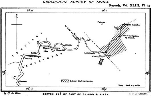
The Upper Tertiaries extend northward through Singkaling Kanti to the village of Selon, beyond which they come to an abrupt end against a deeply dissected mountain area occupied by highly metamorphosed and cleaved sediments. This junction crossed along the course of the Chindwin River, trending northwest and south-east, as indicated on the sketch map. The river runs through a rocky gorge, which was followed for about ten miles to Kyauk-se, where rapids prevent further progress. Along this stretch, the schists strike northeast and southwest and dip northwest at angles between 45° and 60°.
It is important to note that these altered sediments lie exactly on the strike of the Makwari series as mapped by E H Pascoe around Sarameti. The boulders found in the gorge itself and on the sand bank at Maubin are of far more importance. Many large serpentine boulders occur, similar to the intrusions described by E H Pascoe near Sarameti (GSI, Vol XLII 1912).
Mode of Occurrence and Origin of the Gold
In both the Pleistocene terrace gravels and in the recent river deposits, the gold occurs in thin laminae and scales roughly square or oval in outline. The largest pieces met with being only about one-tenth of an inch in length, but the flakes were only half this size in the majority of cases. A considerable proportion of the gold occurs in fine specks, and “float” gold is present. Under the microscope, the flakes are strongly pitted and frequently quite ragged in outline. In no case was anything approaching a nugget found, and no quartz or other vein matter was ever seen attached to the gold. It may, therefore, be assumed that the source of the gold is nowhere near the present site of gravels.
Platinum has been detected in almost every locality but in minimal amounts; its mode of occurrence is the same as that of gold. Together with the platinum occur other rare members of the group, such as osmiridium. The bulk of the heavy residue is composed of magnetite, but zircons and garnets are also common.
J M Maclaren gave it as his opinion that the auriferous gravels of the Chindwin “together with their contained gold, are derived from the Miocene sandstones and conglomerates through which the river runs, and there is, therefore, no likelihood of richer deposits being found higher up the river.” With regard to the deposits in the Uyu River, he remarks, “There can be little doubt, from the position of the Kyobin gravels, that their gold has been derived from the Chaungyi Chaung rather than from the Uyu River. The Chaunggyi gold, again, is itself probably derived from veins in Tertiary igneous rocks towards the head of the stream.”
With the above statements, I am in general agreement. Such gold as is present in the recent river gravels is amply accounted for by the gold occurring in the older gravels now being cut into by the Chindwin River. The origin of the gold in the older gravels themselves is a more difficult question upon which it is useless to speculate, while the geology of the northern frontier of Burma remains unknown.
The question of the origin of the platinum, which is closely bound up with that of the gold, is one that presents serious difficulties. In almost every case in which platinum has been traced to its parent rock, it has been found to occur in chromite segregations associated with serpentines. As we have seen, a serpentine belt extends from the Andamans, more or less continuously, through the Arakan Yoma, Manipur, the Naga Hills, and the upper part of the Chindwin drainage. In the Andamans, chromite is associated with this serpentine, and I found small pockets of chromite in the serpentines near the village of Sibong in Manipur. It is not impossible, therefore, that somewhere to the north, there may be workable deposits of chromite associated with serpentine intrusions and that such chromite deposits may prove to be the source of the platinum and platinoid metals occurring in the older gravels of the Upper Chindwin.
Results of the Assays
The assays were all carried out by Mr A K Banerji, Assistant Curator, under the supervision of Mr J Coggin Brown, Curator of the Geological Museum and Laboratory. The average amount of gold in the Helaw gravels, which may be taken as a type of the recent river gravels, is only half a grain to the cubic yard. Under any conditions, this may be regarded as extremely disappointing, and in view of the natural disadvantages of dredging in such a river as the Chindwin, coupled with the fact that the gold is limited to the upper two feet or so for the banks, no hope whatever of successful exploitation can be entertained.
The Kyobin deposit, which seems to be the best of the older gravels, gave decidedly better results than any of the recent alluvium. In this case, however, the payable gravel is so intimately mixed with barren sand and so inconstant in character that both would have to be taken together. The mass average of the deposit is far too low to enable work to be carried on at a profit. In my opinion, the gold-bearing alluvium of the Chindwin can only be worked on the small scale at present adopted by the local inhabitants, who, by years of experience, are aware of the position of the richer pockets.
Shan Gold-Washing Methods
There are only two places where gold washing is being seriously carried out at present. One of these, namely Helaw, is on the main river, the other being on the Uyu River in the neighbourhood of Kyobin. J M Maclaren described the method practised in recent river gravels. Due to limited space, detailed descriptions of gold-washing in Kyobin, Taung-ni, Hwe-zadaik, Lingyi, Haung-hin or Kyauk-myaung and Hwe-ma-mon etc., could not be mentioned.
Detailed Description of Gold Deposits
For convenience of description, the area under review will be sub-divided as follows: -
A. The main Chindwin River.
B. The Uyu River.
The gold deposits themselves are found in 1) the recent river gravels and 2) the older gravels, probably of Pleistocene age.
A. The main Chindwin River
1. The recent river gravels.
The gold-washing areas are Alon, Thazi, Kani, Kalewa, Maulaikgyi, Helaw and Gyogon, Helaw Island, Ywatha Beach and various minor localities.
2. The older gravels
Pan tests at several points along the outcrop of the older gravels show that gold is always present but invariably in such small quantity as to be far too poor to be worked even by native washers. One cubic yard at Maungkhan gave 28 grains of gold. One cubic yard at Kabani, near Naung-san-kyin, gave 145 grains. These older gravels along the course of the main river are only of interest as showing the source of most, if not all, of the gold in the recent gravel banks.
B. The Uyu River
1. The recent river deposits.
Khaung-ngo: This is the only locality on the Uyu where the recent river deposits are worked for gold, the washing being conducted on sand banks.
2. The older gravels.
Kyobin: The deposit consists of gravel and sand in about equal proportion, and both occur in lenticels, with no constant horizon being present.
When the concentrates were cleaned out and panned, the gold was sold to traders in Maingkaing for Rs 7 as 12, which works out at about one anna a day per man over the whole 1 ½ months and from 3 to 4 annas a day, taking only the actual working days. The gold is separated by amalgamation, and the slight residue of platinum, etc., is thrown away as valueless.
References: Bion, H S. 1913: The Gold-bearing Alluvium of the Chindwin River and Tributaries; Record of Geological Survey of India, Vol XLIII, Part 4.