May 18
Weather report on Cyclone Amphan
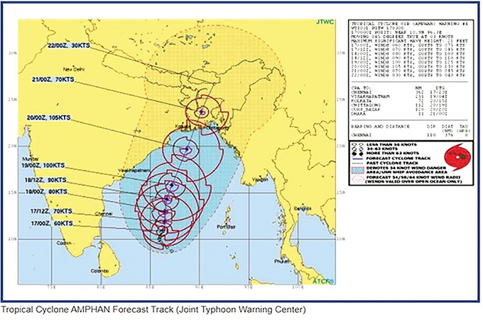
Cyclonic storm Amphan has intensified to a severe cyclonic storm but has not showed no change in trajectory within the southeastern and southwestern region of the Bay of Bengal, according to a weather bulletin issued by the Department of Meteorology and Hydrology at 2 p.m. yesterday.
The severe cyclonic storm was centered 530 miles south-southwest of Paradip (Odisha), India, 615 mile south-southwest of Digha, 675 miles southwest of Khepupara, Bangladesh, 460 miles southwest of Coco Islands, Myanmar, and 605 miles southwest of Pathein. The cyclone currently shows no sign of heading towards Myanmar and is designated a code yellow.
Cyclone Amphan is likely to intensify to a very severe cyclonic storm in the coming 12 hours and move in a north-northeast direction. Amphan is likely to cause scattered thunder showers in Nay Pyi Taw and other states and regions between 17 to 21 of May. It is likely to cause strong winds at 40mph and waves between 8 to 12 feet in height along Ayeyawady delta, Rakhine coastal region and off-shore.
The Emergency Management Department of the Ministry of Social Welfare, Relief and Resettlement states that Cyclone Amphan may reach the northern region of the Bay of Bengal on 19 May and become very severe, category-4, and reach winds of 130mph.
Cyclone Amphan is likely to head towards West Bengal, India and Bangladesh border on 20 May and enter land, according to international meteorology agencies. While the cyclone is currently now heading towards Myanmar, it is estimated to cause strong winds of 50-60mph across the center and northern part of Rakhine’s coastal regions and in southern Chin State.
The ministry urges the public to take the following precautionary measures in the face of possible strong winds, floods, landslides, heavy rains and other natural side effects from the cyclone:
(1) People living or working near the coast and fishermen should regularly listen for news updates to the storm and evacuate early if necessary.
(2) Inspect structural integrity of building residence and reinforce for heavy winds and rains. Cut away trees and branches that may potentially fall on the house.
(3) Have flashlights, candles and matches for emergency use and regularly charge mobile phones.
(4) Refrain from going outside your house during strong winds and heavy rains if possible as falling trees, branches, utility poles and debris blown by the wind can cause injuries. Also refrain from using mobile phones and other electrical appliances at the same time for danger of lightning strikes.
(5) Winds of 50-60mph can knock down huts and blow away roofs. If you feel your house cannot withstand these strong winds, move to the nearest sturdy home or building.
(6) Be careful of soil erosion near rivers and streams and relocate early if necessary.
(7) Flash floods can occur as a result of heavy rains and do not give enough time to move away from them. Be extra careful during nighttime.
(8) Refrain from driving motor vehicles, motorcycles, ox carts or walking along valley streams during thunder showers as strong currents can suddenly overflow.
(9) Avoid electric wires and electricity poles after strong winds and thunder showers. Be careful of snakes and poisonous creatures that may have come out.
(10) Continue adhering to COVID-19 health guidelines when relocating to resilient houses, buildings or designated safe zones.
Members of the public can contact the ministry’s 24hr hot-lines at 067-3404666 and 067-3404777 for more information and updated news on Cyclone Amphan. The ministry will continue updating information through media channels as well.
Ministry of Social Welfare, Relief and Resettlement
(Translated by Zaw Htet Oo)